Watauga, South Dakota
Appearance
Watauga, South Dakota | |
|---|---|
| Coordinates: 45°55′22″N 101°32′34″W / 45.92278°N 101.54278°W | |
| Country | United States |
| State | South Dakota |
| County | Corson |
| Area | |
| • Total | 15.9 sq mi (41.1 km2) |
| • Land | 15.9 sq mi (41.1 km2) |
| • Water | 0.0 sq mi (0.0 km2) |
| Elevation | 2,261 ft (689 m) |
| Population (2000) | |
| • Total | 29 |
| • Density | 1.8/sq mi (0.7/km2) |
| Time zone | UTC-7 (Mountain (MST)) |
| • Summer (DST) | UTC-6 (MDT) |
| ZIP code | 57660 |
| Area code | 605 |
| FIPS code | 46-69260[2] |
| GNIS feature ID | 1258838[1] |
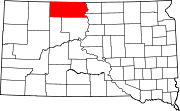
Watauga is an unincorporated community in Corson County, South Dakota, United States. Although not tracked by the Census Bureau, Watauga has been assigned the ZIP code of 57660.
Watauga is a name derived from the Sioux language meaning "foam".[3]
References
[edit]- ^ a b U.S. Geological Survey Geographic Names Information System: Watauga, South Dakota
- ^ "U.S. Census website". United States Census Bureau. Retrieved January 31, 2008.
- ^ Federal Writers' Project (1940). South Dakota place-names, v.1-3. University of South Dakota. p. 68.


